

El Niño is a recurring climate phenomenon that typically develops every two to seven years, when ocean temperatures rise above normal across parts of the equatorial Pacific. These changes can disrupt atmospheric circulation and alter weather patterns far beyond the Pacific Ocean.
Two of the most powerful recent El Niño events occurred in 1997-98 and 2015-16. Both had widespread consequences, including destructive fires in Indonesia and the Amazon, severe drought and crop failures in southern Africa, and intense rainfall and coastal flooding in Southern California. Now, the 2026 El Niño is emerging as another major event, with satellite data suggesting it could rival those historic episodes.
How El Niño Builds Strength in the Pacific
The development of El Niño depends on a complex interaction between ocean temperatures and atmospheric winds.
Under normal conditions, steady trade winds push warm surface water toward the western Pacific Ocean. This causes warm water to accumulate in the west, where the ocean surface sits slightly higher than it does farther east.
When the trade winds weaken, some of that warm water begins moving eastward across the Pacific. The shift can weaken the winds even further or occasionally cause them to reverse direction. This allows additional warm water to spread east, reinforcing the process and raising ocean temperatures and sea levels across the central and eastern Pacific.
Although the underlying process is similar each time, no two El Niño events develop in exactly the same way. Their behavior depends partly on where the warmest water accumulates and how the atmosphere responds to the changing ocean conditions.
"The search for the 'typical' El Niño is very elusive," said Josh Willis, project scientist for sea level missions at NASA's Jet Propulsion Laboratory (JPL). "They're all different in terms of where they land and how their impacts play out."
NASA Satellites Reveal Striking Similarities to 1997
To understand how the current El Niño compares with earlier events, scientists are examining decades of satellite measurements of ocean surface height.
This technique, called satellite altimetry, measures subtle changes in the elevation of the ocean surface. Because seawater expands as it becomes warmer, unusually high sea levels in the central and eastern equatorial Pacific can reveal where heat is accumulating during El Niño.
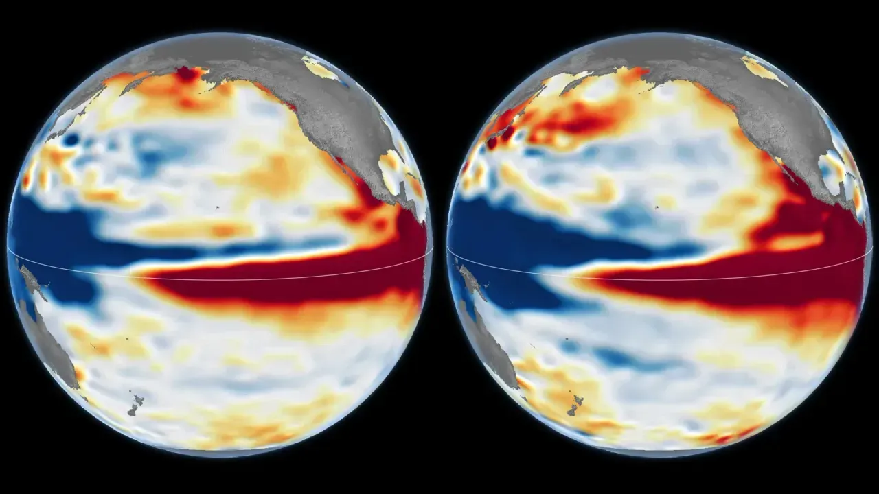
NASA's comparison maps show differences in Pacific Ocean surface height on October 13, 1997 (left), and October 12, 2026 (right). The earlier measurements were collected by the TOPEX/Poseidon satellite, while the newer observations came from the Sentinel-6 Michael Freilich satellite. Scientists at JPL processed both datasets to make the events easier to compare.
The maps use red to identify areas where the ocean surface is higher than its usual level, while white represents normal conditions and blue shows areas where sea levels are below average. To better isolate the effects of El Niño and other temporary natural changes, researchers removed variations associated with seasonal patterns and long-term trends.
One major advantage of these observations is their remarkable consistency. Successive satellite missions have followed nearly identical paths, with overlapping periods of operation that allow scientists to compare measurements across decades.
"What's unique about altimetry is that we have a 35-year record from nearly identical satellites flying almost the same ground track, with each mission overlapping the next," Willis said. "That lets us look back in time and compare this El Niño to what happened in 1997. And right now, this one is on track to be even bigger."
Why the 2026 El Niño Resembles a Historic Climate Giant
The 2026 El Niño intensified much more abruptly than the powerful 1997-98 event. Despite that difference in timing, NASA's satellite measurements from October reveal striking similarities in how the two events are developing.
In both cases, the Pacific displays a pronounced difference in sea level (low in the west and high in the east). The observations also show elevated, unusually warm water stretching eastward along the equator until it reaches the coast of South America.
These similarities suggest that the 2026 event could produce weather effects resembling those experienced during the 1997-98 El Niño. That earlier episode brought substantial rainfall to California and other parts of the southern United States, raising the possibility of comparable conditions during the coming winter.
However, the powerful 2015-16 El Niño demonstrates why similarities in overall strength do not necessarily translate into identical weather impacts.
For that comparison, NASA scientists also examined ocean surface height measurements from October 12, 2015, recorded by the Jason-2 satellite. The data were placed alongside observations from approximately the same time of year in 1997 and 2026.
Although the 2015 event also featured exceptionally warm water and elevated sea levels along the equator, that warm water did not extend toward the South American coast as strongly as it did during the other two events.
The resulting rainfall patterns were different as well. During the winter of 2015-16, much of the precipitation associated with El Niño was concentrated over Central America and the southeastern United States, while Mexico experienced significant flooding.
Will El Niño Bring Extreme Weather in Winter 2026-27?
The latest observations have prompted scientists to closely monitor how the 2026 El Niño develops and what it could mean for weather conditions in the months ahead.
In its October 8, 2026, outlook, the National Oceanic and Atmospheric Administration (NOAA) estimated an 83 percent chance that strong to very strong El Niño conditions would occur during the first three months of 2027.
That forecast points to the potential for a particularly significant climate event, but it does not establish exactly where the most severe effects will occur.
El Niño can influence weather across much of the planet by changing the movement of heat and moisture through the atmosphere. However, those effects become increasingly difficult to predict farther from the tropical Pacific, where other atmospheric processes can alter or weaken the expected patterns.
As a result, even the strong resemblance between the 2026 and 1997 events cannot guarantee that the coming winter will unfold in the same way.
"There's always a bit of a dice roll here," Willis said. "Just because this El Niño looks like 1997 doesn't mean it will be exactly the same -- it's just our best guess at the moment."
The unprecedented consistency of the satellite record gives researchers a valuable way to recognize familiar patterns and evaluate the scale of the developing El Niño. But whether 2026-27 ultimately matches the extreme weather of previous historic events will depend on how the ocean and atmosphere interact in the months ahead.