

By ,
Bay of Bengal system live updates: As per IMD, cyclone Akvan is likely to intensify further and move west-northwestwards and cross Andhra Pradesh and Yanam coasts between Nellore and Tuni, around noon of November 20, 2026 as a very severe cyclonic storm.
49 Sec agoTamil Nadu and Puducherry weather forecast
10 Mins agoHow fast will the winds blow?
12 Mins agoCM Naidu directs officials to step up cyclone preparedness
19 Mins agoAndaman-Nicobar Islands lieutenant governor says ‘disaster control force completely prepared’
25 Mins agoCyclone ‘Akvan’ likely to make landfall along Andhra-Yanam coast
39 Mins agoCyclone 'Akvan' likely to cause heavy rain in Kolkata, Howrah
49 Mins agoAndhra CM Naidu directed officials to deploy NDRF and SDRF teams in advance
1 Hr 4 Mins agoOdisha to see heavy rain on Nov 18
1 Hr 10 Mins agoRough sea conditons to prevail till Nov 20
1 Hr 18 Mins agoAndhra to see third cyclone in 3 weeks
1 Hr 31 Mins agoCyclone ‘Akvan’ to cross Andhra coast between Nellore and Tuni
1 Hr 40 Mins agoOdisha orders early evacuation
1 Hr 49 Mins agoVery heavy rain to hit parts of Andhra
1 Hr 56 Mins agoWarning issued for Andhra fishermen
4:51 PM IST, Nov 16Andhra's Konaseema, Kakinada and East Godavari to be affected
4:43 PM IST, Nov 16CM Naidu asks officials to ‘take precautions’ as cyclone poised to affect coast
4:40 PM IST, Nov 16IMD shares graphic images of approaching cyclonic system
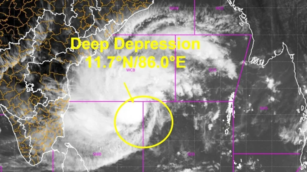
4:35 PM IST, Nov 16Where does the deep depression currently lie?
4:31 PM IST, Nov 16System to turn into severe cyclonic storm on Nov 17
4:22 PM IST, Nov 16Deep depression to intensify into cyclonic storm by today evening
4:18 PM IST, Nov 16Deep depression moves north-northwestwards
4:09 PM IST, Nov 16Cyclone ‘Akvan’ expected to reach Andhra coast by Nov 19
8:23 AM IST, Nov 16Odisha aims for ‘zero casualties’ target as it steps up efforts to minimise impact
8:15 AM IST, Nov 16Odisha braces for heavy rain as cyclone looms over Bay of Bengal
8:04 AM IST, Nov 16Officials’ weekend leaves cancelled as third cyclone looms
7:56 AM IST, Nov 16Rain likely in Bengal as cyclone forms over Bay of Bengal
7:26 AM IST, Nov 16Odisha on alert as third cyclone looms
7:19 AM IST, Nov 16Weather system to turn into cyclonic storm
6:47 AM IST, Nov 16IMD warns of another cyclonic storm over Bay of Bengal
Bay of Bengal system live updates: A deep depression over the Bay of Bengal is likely to strengthen into a cyclonic storm by the evening of November 16 and further intensify into a severe cyclonic storm by November 17, before moving towards the Andhra Pradesh coast over the following days, the India Meteorological Department (IMD) said on Monday....Read More
IMD in its latest bulletin said, “The deep depression over southeast and adjoining southwest Bay of Bengal moved north-northwestwards with the speed of 17 kmph during past 06 hours on November 16.”
It lay about 620 km northeast of Trincomalee (Sri Lanka), 730km west of Sri Vijaya Puram (Andaman and Nicobar Islands), 650 km east-southeast of Chennai (Tamil Nadu), 730 km south-southeast of Visakhapatnam (Andhra Pradesh) and 850 km south of Gopalpur (Odisha).
It is very likely to continue to move north-northwestwards, intensify further into a cyclonic storm over the central parts of south and adjoining westcentral Bay of Bengal today evening and into a severe cyclonic storm over westcentral Bay of Bengal in the evening of November 17.
Thereafter, it is likely to intensify further and move west-northwestwards and cross Andhra Pradesh and Yanam coasts between Nellore and Tuni, around noon of November 20, 2026 as a very severe cyclonic storm with the maximum sustained wind speed of 120-130 kmph gusting to 145 kmph.
If and when the deep depression turns into a cyclone or a cyclonic storm, it will be called ‘Akvan’, according to the list maintained by the WMO/ESCAP panel on tropical cyclones.
Odisha steps up preparedness
The Odisha government has alerted all districts, particularly those in the southern and coastal regions, to remain prepared to deal with any adverse weather conditions as a possible third cyclone in three weeks brews over the Bay of Bengal.
A 24-hour control room will remain operational in all districts, while NDRF, ODRAF and Fire Services and Emergency personnel will be kept ready for rescue and evacuation operations, an official said, news agency PTI reported.
The precautionary measures are being taken as cyclone Arnab wreaked havoc in the southern districts in October and cyclone Murasu triggered rainfall in the region earlier this month, disaster management minister Suresh Pujari said.
The region was severely affected by devastating floods during cyclone Arnab, which made landfall in neighbouring Andhra Pradesh on October 28.
Follow all the updates here:
Bay of Bengal system live updates: Tamil Nadu and Puducherry weather forecast
Bay of Bengal system live updates: Cyclone Akvan is likely to cause heavy rain in Chennai and neighbouring districts from November 17.
The IMD has forecast heavy rain accompanied by thunderstorms, lightning and gusty winds reaching 40-50 kmph in Chennai, Tiruvallur and Chengalpattu from November 17.
From November 18, heavy rainfall is likely in Kanchipuram, Ranipet, Tiruvannamalai, Villupuram, Cuddalore and Mayiladuthurai districts, as well as Puducherry.
Bay of Bengal system live updates: How fast will the winds blow?
Bay of Bengal system live updates: The IMD has warned of extremely strong winds along the Andhra Pradesh and Yanam coasts as the cyclone approaches.
Maximum sustained wind speeds are likely to reach 120-130 kmph, with gusts of up to 145 kmph during the expected landfall.
Bay of Bengal system live updates: CM Naidu directs officials to step up cyclone preparedness
Bay of Bengal system live updates: CM Naidu directed officials to take precautionary measures in view of the cyclone expected to affect the Coastal Andhra region on November 20, said an official press release.
Naidu also instructed officials to continuously monitor the weather system.
Bay of Bengal system live updates: Andaman-Nicobar Islands lieutenant governor says ‘disaster control force completely prepared’
Amid concerns over the approaching cyclone, Andaman and Nicobar Islands lieutenant governor Dinesh Sharma said that disaster response agencies and the armed forces were on high alert to deal with any eventuality.
He told ANI, "Our disaster control force is always completely prepared there. Our Navy, Air Force, and Army, all three remain on high alert in our islands. While we have no control over natural disasters, we ensure that factors contributing to disasters do not occur, and if a disaster strikes under any unfortunate circumstances, complete safety arrangements are immediately in place. Right now, there is no cause for such concern... in the normal course, minor cyclones come and go."
Bay of Bengal system live updates: Cyclone ‘Akvan’ likely to make landfall along Andhra-Yanam coast
Bay of Bengal system live updates: As per IMD, cyclone ‘Akvan’ is likely to intensify further and move west-northwestwards and cross Andhra Pradesh and Yanam coasts between Nellore and Tuni, around noon of November 20, 2026 as a very severe cyclonic storm with the maximum sustained wind speed of 120-130 kmph gusting to 145 kmph.
Bay of Bengal system live updates: Cyclone 'Akvan' likely to cause heavy rain in Kolkata, Howrah
Bay of Bengal system live updates: The India Meteorological Department (IMD) on Monday forecast heavy rains in multiple districts of south Bengal starting November 19. The warning till November 21 comes as cyclonic storm ‘Akvan’ brews in the Bay of Bengal. As per IMD, dry weather conditions will prevail over north Bengal during the next five days.
Light to moderate showers were recorded in isolated parts of Jalpaiguri district in north Bengal over the past 24 hours, while the remaining districts of West Bengal experienced predominantly dry weather conditions. Rainfall activity accompanied by thunderstorms and gusty winds is expected to increase across several parts of south Bengal, including Kolkata, Howrah, Hooghly, Nadia, East Burdwan, North 24 Parganas, West Midnapore and Jhargram, as per IMD.
Bay of Bengal system live updates: Andhra CM Naidu directs officials to deploy NDRF, SDRF teams in advance
Bay of Bengal system live updates: The cyclone is likely to affect several areas, including Konaseema, Kakinada, East Godavari, West Godavari, Krishna, NTR and Guntur districts.
In view of the impending threat, the Andhra CM Naidu directed officials to deploy NDRF and SDRF teams in advance and keep electricity department personnel ready to restore power supply on a war footing in the event of disruptions.
Bay of Bengal system live updates: Odisha to see heavy rain on Nov 18
Bay of Bengal system live updates: As per IMD, light to moderate rain is expected at some places while heavy rain is likely at isolated places in Odisha on November 18. Light to moderate rainfall at most places with heavy to very heavy rainfall at isolated places during November 19 and 21.
Bay of Bengal system live updates: Rough sea conditions to prevail till Nov 20
Bay of Bengal system live updates: Rough sea conditions will prevail till November 20 in the Andaman Sea and off the Andaman and Nicobar Islands, Bay of Bengal, North Tamil Nadu and Puducherry coasts, Andhra Pradesh and Yanam coast and Odisha coast.
Bay of Bengal system live updates: Andhra to see third cyclone in 3 weeks
Bay of Bengal system live updates: Andhra Pradesh will face the third cyclone in three weeks as deep depression over the southeast and adjoining southwest Bay of Bengal is likely to intensify into a severe cyclonic storm, named Akvan, by Monday evening and barrel towards the state.
Bay of Bengal system live updates: Cyclone ‘Akvan’ to cross Andhra coast between Nellore and Tuni
Bay of Bengal system live updates: Cyclone Akvan is likely to intensify further and move west-northwestwards and cross Andhra Pradesh and Yanam coasts between Nellore and Tuni, around noon of November 20, 2026 as a very severe cyclonic storm with the maximum sustained wind speed of 120-130 kmph gusting to 145 kmph.
Bay of Bengal system live updates: Odisha orders early evacuation
Bay of Bengal system live updates: The Odisha government on Monday directed district administrations in the southern region to begin early evacuation of vulnerable areas as a deep depression over the Bay of Bengal intensified, officials said.
The weather system is likely to develop into a very severe cyclonic storm before reaching the Andhra Pradesh coast around November 19 night, they said.
The district administrations have been asked to identify vulnerable locations and move people to safer places ahead of the expected heavy rainfall, they added.
Ganjam Collector Keerthi Vasan V said the district administration had identified landslide-prone locations and low-lying areas that could be inundated during the cyclone.
(via PTI)
Bay of Bengal system live updates: Very heavy rain to hit parts of Andhra
Bay of Bengal system live updates: Under the influence of the system, heavy to very heavy rainfall at a few places, with isolated extremely heavy rainfall likely over coastal Andhra Pradesh and Yanam during 19-20 November and isolated heavy to very heavy rainfall likely over Tamil Nadu, Puducherry and Karaikal during 18-19 November; Telangana on 20 November, the IMD stated in the latest update.
IMD predicted fairly widespread to widespread rainfall likely over Odisha during 19-22 November.
Isolated to scattered rainfall is likely over Odisha on 18 November, it further said.
Bay of Bengal system live updates: Warning issued for Andhra fishermen
Bay of Bengal system live updates: Authorities in Andhra Pradesh have issued a warning, urging fishermen to stay away from the sea as a deep depression over the Bay of Bengal threatens to develop into a powerful cyclone. As per PTI, APSDMA managing director Prakhar Jain cautioned that coastal districts are likely to experience strong, gusty winds and heavy rainfall, and called on farmers and residents to remain alert and follow safety advisories.
According to the latest projections, the weather system could intensify into a cyclonic storm by Monday evening, strengthen further into a severe cyclonic storm on November 17, and potentially reach very severe cyclonic storm intensity near the Andhra Pradesh coast by November 19. The forecast has put the state on alert as it faces the prospect of its third cyclone in less than three weeks.
Bay of Bengal system live updates: Andhra's Konaseema, Kakinada and East Godavari to be affected
Bay of Bengal system live updates: The cyclone is likely to affect several areas, including Konaseema, Kakinada, East Godavari, West Godavari, Krishna, NTR and Guntur districts.
In view of the impending threat, the Andhra CM directed officials to deploy NDRF and SDRF teams in advance and keep electricity department personnel ready to restore power supply on a war footing in the event of disruptions.
He also instructed officials to take necessary steps to divert floodwaters resulting from heavy rainfall into reservoirs to ensure effective water management, the press release added.
The southern state was battered by two cyclones in quick succession recently, Arnab and Murasu, flattening lakhs of acres of crops and inflicting a loss of nearly ₹7,000 crore, as estimated by the government.
(via PTI)
Bay of Bengal system live updates: CM Naidu asks officials to ‘take precautions’ as cyclone poised to affect coast
Bay of Bengal system live updates: Andhra Pradesh chief minister N Chandrababu Naidu on Monday directed officials to take precautionary measures in view of a looming cyclone expected to affect the coastal regions of the state on November 20.
A deep depression hovering over parts of the Bay of Bengal is likely to intensify into a cyclonic storm by Monday evening, severe cyclonic storm by November 17 and further into a very severe cyclonic storm near the Andhra Pradesh coast around November 19, compelling the southern state to brace for its third cyclone within three weeks.
"Naidu directed officials to take precautionary measures in view of the cyclone expected to affect the Coastal Andhra region on November 20," said an official press release.
Bay of Bengal system live updates: IMD shares graphic imageof approaching cyclonic system
Bay of Bengal system live updates: The cyclonic storm forming in the Bay of Bengal is expected to reach the coast of Andhra Pradesh by November 19, 2026.
Bay of Bengal system live updates: Where does the deep depression currently lie?
Bay of Bengal system live updates: The deep depression over southeast and adjoining southwest Bay of Bengal moved north-northwestwards with the speed of 17 kmph during past 06 hours and lay centered at 11:30 hours IST of today over the same region. It about 620 km northeast of Trincomalee (Sri Lanka), 730km west of Sri Vijaya Puram (Andaman & Nicobar Islands), 650 km east-southeast of Chennai (Tamil Nadu), 730 km south-southeast of Visakhapatnam (Andhra Pradesh) and 850 km south of Gopalpur (Odisha).
Bay of Bengal system live updates: System to turn into severe cyclonic storm on Nov 17
Bay of Bengal system live updates: As per IMD, the system will turn into a severe cyclonic storm over westcentral Bay of Bengal in the evening of November 17, 2026. Thereafter, it is likely to intensify further and move west-northwestwards and cross Andhra Pradesh and Yanam coasts between Nellore and Tuni, around noon of November 20, 2026 as a very severe cyclonic storm with the maximum sustained wind speed of 120-130 kmph gusting to 145 kmph.
Bay of Bengal system live updates: Deep depression to intensify into cyclonic storm by today evening
Bay of Bengal system live updates: According to IMD, the system is very likely to continue to move north-northwestwards, intensify further into a cyclonic storm over the central parts of south and adjoining westcentral Bay of Bengal by November 16 evening.
Bay of Bengal system live updates: Deep depression moves north-northwestwards
Bay of Bengal system live updates: IMD in its latest bulletin said that the deep depression over southeast and adjoining southwest Bay of Bengal moved north-northwestwards with the speed of 17 kmph during past 06 hours on November 16.
It lay about 620 km northeast of Trincomalee (Sri Lanka), 730km west of Sri Vijaya Puram (Andaman and Nicobar Islands), 650 km east-southeast of Chennai (Tamil Nadu), 730 km south-southeast of Visakhapatnam (Andhra Pradesh) and 850 km south of Gopalpur (Odisha).
It is very likely to continue to move north-northwestwards, intensify further into a cyclonic storm over the central parts of south and adjoining westcentral Bay of Bengal today evening and into a severe cyclonic storm over westcentral Bay of Bengal in the evening of November 17.
Thereafter, it is likely to intensify further and move west-northwestwards and cross Andhra Pradesh and Yanam coasts between Nellore and Tuni, around noon of November 20, 2026 as a very severe cyclonic storm with the maximum sustained wind speed of 120-130 kmph gusting to 145 kmph.
Bay of Bengal system live updates: Cyclone ‘Akvan’ expected to reach Andhra coast by Nov 19
Bay of Bengal system live updates: Cyclonic storm forming in the Bay of Bengal is expected to reach the coast of Andhra Pradesh by November 19, 2026, stated IMD in a post on X.
Bay of Bengal system live updates: Heavy rain warning in four south Bengal districts from November 19
Bay of Bengal system live updates: The cyclonic storm brewing over the Bay of Bengal is likely to bring heavy rain to some south Bengal districts from November 19 to 21, the IMD said on Monday.
The storm is likely to bring heavy rain to South 24 Parganas, Purba Medinipur, Paschim Medinipur and Jhargram districts, it added.
The system will also cause thunderstorms, accompanied by gusty winds, over most south Bengal districts, including Kolkata, the IMD said.
It advised fishermen not to venture into the sea on November 19 and 20, according to a PTI report.
(via PTI)
Bay of Bengal system live updates: Orange alert in Tamil Nadu
Bay of Bengal system live updates: The IMD has issued an orange alert for Chennai and some other parts of Tamil Nadu for November 18 (Wednesday) and November 19 (Thursday), forecasting very heavy rainfall in these regions.
For November 20, Friday, the weather department has put the state on a yellow alert as of now.
Newer Updates
Older Updates